Basin Information
Basin Description
The geographic area covered by this GSP and managed by ASRBGSA and FCGMA includes the entire ASRVGB (DWR Basin No. 4‑007), as defined by DWR Bulletin No. 118, “California’s Groundwater,” Update 2020 (DWR, 2020a). The Basin is in the southeastern portion of Ventura County near the City of Thousand Oaks and the City of Camarillo (Figure ES-02). The ASRVGB is bordered by the following basins: Tierra Rejada (4-015) to the east, Conejo (4-101) to 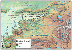 the south, Pleasant Valley Basin (4-006) to the west, and Las Posas Valley (4-008) to the north.
Land use in the Basin is generally split between agricultural and low-density residential (53% and 35%, respectively), with agricultural land making up most of the western half of the Basin and residential land making up the eastern half of the Basin. Approximately 70% of the Basin is protected land under the Save Open Space & Agricultural Resources (SOAR) program, which includes agricultural, residential, open space, and undeveloped land. Thus, further intensive development is not expected to occur within the Basin for the foreseeable future. The principal land use planning agency in the Basin is the County of Ventura, which recently completed its 2040 General Plan.
Basin Setting and Groundwater Conditions Overview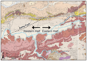
The ASRVGB is in an elongated east-trending valley and consists of multiple layers of alternating fine- and coarse-grained unconsolidated deposits, semi-consolidated deposits, and consolidated formations underlain by volcanic bedrock. The Basin is roughly centered on an east-west oriented structural syncline and the sedimentary deposits are thickest in the center and westernmost areas, thinning out to the Basin margins. The aquifer system is semi-confined and is characterized by distinct upper and lower groundwater producing zones in the west with the stratification absent or not apparent to the east; the upper and lower groundwater producing zones are treated as a single principle aquifer for purposes of sustainable groundwater management in this initial GSP. To facilitate discussion within the GSP, the Basin has been subdivided into two areas, the western half and eastern half. In addition, a key hydraulic feature within the Basin is the Bailey Fault, which acts as a relative barrier to flow, separating the northwestern third of the Basin from the rest of the Basin (Figure ES-03).
Inflow into the Basin comes from mountain block fracture flow from the Conejo Volcanics from the south and east, infiltration of streamflow, recharge as infiltration of precipitation and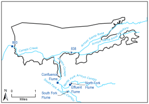 agricultural and urban return flows, and mountain front recharge from the north. There is a small component of underflow from the Pleasant Valley Basin to the west but is not well-constrained by data and is quantified within the range of uncertainty of the numerical model. The Arroyo Conejo and Conejo Creek are the major surface water features recharging the groundwater in the south-central and southwestern area of the Basin (Figure ES-04)– this surface water system is a perennial creek due to a constant source of effluent from the Hill Canyon Wastewater Treatment Plant (WWTP). Groundwater extraction is the primary outflow component for the Basin, and shallow groundwater also discharges to the Conejo Creek in the southwestern area.